Hiking in Salt Lake City: 10 Best Trails & Local Guide
 Hiking in Salt Lake City: 10 Best Trails & Local Guide
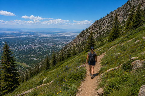
Salt Lake City is one of the best cities in America for hiking. With the Wasatch Mountains rising dramatically to the east and the Oquirrh Mountains to the west, SLC sits inside a natural amphitheater of trails. You can be sitting at a desk at 4:00 PM and standing on a 9,000-foot summit by 6:30 PM. Whether you are lacing up for the first time or chasing your next peak, Salt Lake City delivers world-class hiking just minutes from downtown.
This guide covers the 10 best trails in the valley, broken down by difficulty, plus everything you need to know before you go — canyon rules, seasonal tips, gear, and safety.
Why Salt Lake City Is a Hiker’s Paradise
Few cities offer what Salt Lake City does: over 200 miles of trails accessible within 30 minutes of downtown. The elevation diversity is unmatched. The Wasatch Front gives hikers four distinct seasons, each with its own character — wildflowers in spring, alpine lakes in summer, golden aspens in fall, and frozen waterfalls in winter.
The geography is naturally divided into distinct zones:
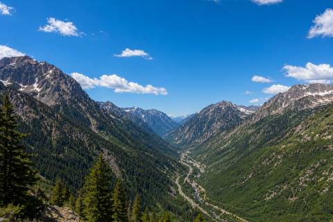
The Canyons — Big Cottonwood and Little Cottonwood offer alpine lakes and jagged granite peaks. These are the crown jewels of SLC hiking.
The Foothills — The Bonneville Shoreline Trail runs for miles along the ancient Lake Bonneville waterline, offering a high-desert escape right above the city.
The Islands — Antelope Island rises from the Great Salt Lake, offering exposed ridgelines, bison sightings, and sweeping 360-degree views unlike anything else in the valley.
The 10 Best Hiking Trails in Salt Lake City
Easy Trails
1. Ensign Peak Distance: 1.8 miles round trip | Elevation Gain: 400 ft | Trailhead: Ensign Peak Rd. The classic Salt Lake City beginner hike. Short, accessible, and sitting just above the State Capitol, Ensign Peak delivers one of the best views of the downtown grid and the Great Salt Lake. Perfect for a quick morning outing or a sunset walk.
2. Silver Lake Loop Distance: 1 mile | Elevation Gain: Minimal | Trailhead: Brighton, Big Cottonwood Canyon. Located at the top of Big Cottonwood Canyon near Brighton Ski Resort, this flat boardwalk loop circles a stunning alpine lake surrounded by wildflowers in summer and snow in fall. It is the gold standard for family-friendly hiking in Salt Lake City — stroller accessible and consistently beautiful.
3. Donut Falls Distance: 3 miles round trip | Elevation Gain: 400 ft | Trailhead: Mill D, Big Cottonwood Canyon. A local rite of passage. The trail leads to a waterfall that drops through a natural hole in the cave ceiling — the “donut” — creating one of the most unique geological features in the Wasatch. In winter, the falls freeze into a dramatic ice sculpture. Note: no dogs allowed in Big Cottonwood Canyon.
Moderate Trails
4. Grandeur Peak (East Route) Distance: 6 miles round trip | Elevation Gain: 2,600 ft | Trailhead: Church Fork, Millcreek Canyon. Accessed via Millcreek Canyon, the east route up Grandeur Peak is shaded, well-maintained, and far less punishing than the exposed west face. The summit at 8,299 feet delivers a full panoramic view of the Salt Lake Valley. Dogs are welcome in Millcreek Canyon — on even-numbered days they can be off-leash.
5. Bell Canyon Reservoir Distance: 5 miles round trip | Elevation Gain: 1,600 ft | Trailhead: Bell Canyon Trailhead, Sandy. A steady, rewarding climb through rocky terrain to a gorgeous high-alpine reservoir framed by granite walls. This is one of the valley’s best-kept moderate hikes — less crowded than the Cottonwood Canyon trails but just as scenic.
6. Cecret Lake Distance: 1.5 miles round trip | Elevation Gain: 360 ft | Trailhead: Albion Basin, Alta. Pronounced “Secret” — and it feels like one. Tucked into the Albion Basin at Alta, this short hike bursts with wildflowers in mid-July and offers jaw-dropping views of the surrounding peaks. Note: no dogs allowed here, and the road to the trailhead typically opens in late June.
Difficult Trails
7. Lake Blanche Distance: 6.4 miles round trip | Elevation Gain: 2,700 ft | Trailhead: S Fork Picnic Area, Big Cottonwood Canyon. Often called the most beautiful hike in the Wasatch. The trail climbs steadily through pine forest before opening into a dramatic alpine basin where Sundial Peak reflects off the still water of Lake Blanche. Start before 8:00 AM on weekends — this one gets crowded fast.
8. Frary Peak — Antelope Island Distance: 6.7 miles round trip | Elevation Gain: 1,900 ft | Trailhead: Frary Peak Trailhead, Antelope Island. The highest point on Antelope Island at 6,596 feet. The trail is fully exposed with no shade, so an early start is essential. The payoff is a 360-degree view of the Great Salt Lake, the Wasatch, and the Oquirrh Mountains all at once — one of the most unique vantage points in Utah.
9. Mount Olympus Distance: 8 miles round trip | Elevation Gain: 4,100 ft | Trailhead: Wasatch Boulevard, Holladay. The twin-peaked icon visible from almost anywhere in the valley. Mount Olympus is a serious hike with loose rock scrambling near the summit. Do not attempt this in midday summer heat — start by 5:00 AM or wait until September. The summit at 9,026 feet is worth every step.
10. Mount Timpanogos Distance: 14–17 miles round trip | Elevation Gain: 4,900 ft | Trailhead: Timpooneke or Aspen Grove. About 45 minutes south of Salt Lake City, but a Wasatch bucket list item locals treat as their own. Timp is the most beloved high-altitude trek in the region. Pro tip: start in the dark and you will see one of the best sunrises of your life. Note: a timed entry permit is required in summer months.
Big Cottonwood vs. Little Cottonwood Canyon: Which Is Right for You?
Dogs allowed: No -> both are protected watersheds
Big Cottonwood is best for: Lakes, families, and moderate hikes
Little Cottonwood is best for: Granite, advanced routes, and peak-bagging
Big Cottonwood signature hike: Lake Blanche
Little Cottonwood signature hike: Pfiefferhorn
Big Cottonwood ski resorts: Brighton & Solitude
Little Cottonwood ski resorts: Snowbird & Alta
Parking tip for both: Arrive before 8:00 AM on weekends
Seasonal Guide to Hiking in Salt Lake City
Spring (Mar–May) — Mud at lower elevations, snow at the top. Stick to the Bonneville Shoreline Trail to avoid destroying muddy alpine trails.
Summer (Jun–Aug) — Wildflowers and heat. Start Mount Olympus by 5:00 AM or wait until September.
Fall (Sep–Nov) — Peak foliage, cooler temps. Millcreek Canyon is the best canyon for fall colors.
Winter (Dec–Feb) — Packed snow, frozen waterfalls. Donut Falls becomes a winter wonderland — bring microspikes.
Know Before You Go
Watershed Rules Big Cottonwood, Little Cottonwood, and City Creek Canyons are protected watersheds. No dogs and no swimming. For dog-friendly hikes, head to Millcreek Canyon, Neff’s Canyon, or the Bonneville Shoreline Trail foothills.
Parking & Fees Millcreek Canyon charges $5 per car (paid on exit). Antelope Island costs $15–$20 per vehicle. Most Wasatch trailheads are free, though some fill up by 7:00 AM on summer weekends.
Wildlife Moose, rattlesnakes, and mountain lions all live in the Wasatch. Give moose a very wide berth — they are far more aggressive than they look. If you hear a rattle near dry brush, back away slowly and calmly.
Essential Gear Checklist for Wasatch Day Hikes
✅ Water — minimum 2 liters; Utah’s air is extremely dry
✅ Sunscreen and a hat — high elevation UV is intense year-round
✅ Layers — mountain weather changes fast above 8,000 feet
✅ Trekking poles — especially helpful on Mount Olympus and steep descents
✅ Trail snacks — high-calorie and lightweight
✅ Downloaded offline map — cell service is unreliable in canyons
✅ Microspikes — essential for any hike, October through April
✅ Headlamp — in case your hike runs long
✅ First aid kit — blisters happen
Go Deeper: More SLC Hiking Guides on Seven Slopes
These posts dive deeper into specific trails, canyons, and destinations covered in this guide. Each one is worth reading before your next trip into the Wasatch.
🏔️ Exploring the Natural Wonders of Antelope Island State Park Antelope Island is unlike any other hiking destination near Salt Lake City. This guide covers everything from Frary Peak to the Buffalo Point overlook, plus what to know about bison, sunsets over the Great Salt Lake, and how to make the most of your visit to this underrated state park.
🌲 Discover the Magic of Cottonwood Canyons in the Summer Big and Little Cottonwood Canyons are the heart of Salt Lake City hiking. This post explores what makes summer in the Cottonwoods so special — from alpine wildflowers and hidden lakes to the cool canyon air that makes even hot July days feel manageable.
👨👩👧 Discovering Family-Friendly Hikes in the Wasatch Mountains Hiking with kids in SLC doesn’t have to mean short and boring. This guide highlights the best family-friendly Wasatch trails, including tips on which hikes are stroller-friendly, which ones keep kids engaged, and how to make the outdoors fun for every age group.
🌿 Exploring Salt Lake City’s Scenic Park Trails Not every great walk in Salt Lake City requires driving to a canyon. This post covers the best in-city park trails — from Red Butte Garden to Liberty Park to City Creek Canyon — perfect for a quick outing when you don’t have time to head into the mountains.
💧 5 Great Water Destination Hikes of the Wasatch Front Some of the best hikes in the Wasatch lead to water — lakes, waterfalls, and canyon streams that make the destination as rewarding as the journey. This guide highlights five hikes where the payoff is a beautiful body of water, including Bell Canyon Reservoir and more.
Pack more water than you think you need, respect Leave No Trace principles, and we will see you on the ridgeline.